
Aviation climate effects of non-CO2 emissions depend on location and time of emission. In order to mitigate aviation’s climate effect, the mitigation strategy of climate-optimized trajectories aims to avoid flying through those regions of the atmosphere which are particularly sensitive to aviation emissions (e.g. regions where persistent contrails with a large climate effect are forming).
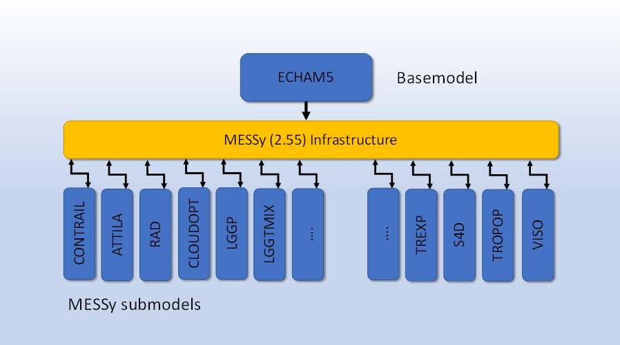
Figure 1. Overview of the EMAC/MESSy model structure
In order to avoid these regions of the atmosphere, detailed knowledge from climate science is required, where, depending on the actual weather conditions and synoptic weather patterns, regions with a large climate effect are located. Such information needs to be made available to flight planning tools and trajectory optimization in order to evaluate if alternative aircraft trajectories with lower climate effect exist. This kind of information is called Climate Change Functions (CCFs), measuring climate effects of aviation emissions (e.g. in Kelvin per NOx emitted). Currently, prototypes of such CCFs have been calculated for the North Atlantic flight corridor, however, no systematic analysis for other regions of the globe were conducted so far.
For that purpose, within the ClimOP project, the aim is to expand the geographic scope of CCFs to more global coverage, starting with expanding over the Northern Hemispheric extratropics, as well as lower (tropical) latitudes. The calculation of CCFs relies on a Lagrangian approach, which has been implemented in the global chemistry model EMAC. Lagrangian Trajectories, and contrail microphysics are calculated in the corresponding EMAC submodels, ATTILA and CONTRAIL, respectively.
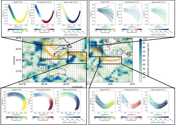
Figure 2. EMAC grid (grey) and location of the time regions (red). Air parcel trajectories (orange) started from the EMAC grid cell in which the time-region grid point is located; Black boxes: Height (left), temperature (middle) and water vapour (right) temporal evolution for the different trajectories, Peter et al., 2021
Figure 1 shows the modular modelling approach which allows the integration of Lagrangian transport in the Gaussian model domain. This comprehensive numerical modelling concept enables the identification of climate change functions for other regions of the globe which quantify the climate effects in a given realistic weather situation.
A schematic view of the EMAC model setup and experiment design is shown in Figure 2. For a realistic distribution of regions with supersaturation over ice (indicated by dark blue color), a set of trajectories with 50 members each is started, and contrail microphysics is calculated along these Lagrangian trajectories. In the figure, regions with a high contrail formation potential are marked in dark colors. Depending on dynamical conditions (advection, convection), air parcels are transported in the atmosphere and contrails can either grow or dry as a function of ambient conditions. An upward transport shows a decrease in pressure, which is in general associated with decreasing temperatures. Under these conditions, due to adiabatic cooling, the air parcels stay supersaturated, and contrails that have been formed have the potential to have a long lifetime and induce a change in the radiative transfer in the atmosphere, which is measured by the radiative forcing (RF) concept.
With having such CCFs for large areas of the globe available, it is possible to perform an analysis of the overall mitigation gain of climate-optimized trajectories.
Authors: Sigrun Matthes, Patrick Peter, Deutsches Zentrum für Luft- und Raumfahrt (DLR)